
The Story Behind the MRV Relief Map

The map after the green background had been completed.
If you’ve spent any time in the Mad River Valley Welcome Center, chances are you’ve found yourself standing in front of the map—leaning in, tracing ridge-lines with your eyes, pointing out dirt roads you’ve driven and trails you’ve skied or hiked. It’s hard to miss. And as it turns out, it’s got an even better story than we first realized.
How the Map Reappeared
The idea for a relief map first resurfaced while we were applying for a Vermont Outdoor Recreation Economic Collaborative (VOREC) grant. We were imagining what would make the Welcome Center feel more engaging, more Mad River Valley. A large, tactile relief map felt like just the thing—something that would invite curiosity, conversation, and a sense of place.
When I floated the idea to Joshua Schwartz, Director of the MRV Planning District, he said, almost offhandedly, “I think there’s one in Warren!”
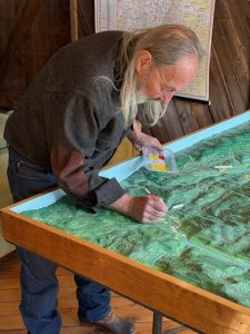
Artist, Dave Reed adds finishing touches to the Waterbury portion of the map in February 2026.
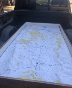
An hour later, we were climbing into the attic of the Warren Town Hall. And sure enough, leaning against a wall, we found it: a 4’ x 8’ relief map of the Mad River Valley, covered in scratched plexiglass and a thick layer of dust. Once the plexiglass came off, the craftsmanship underneath was immediately apparent—an incredibly detailed topographic model with 100‑foot elevation contours. Even better, its footprint perfectly matched the area covered by our Mad River Valley Recreation Map: from Granville to Middlesex along the Mad River, framed by the Green Mountains and the Northfield Range.
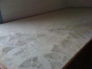
At first glance, the map was mostly white, with timber lots carefully labeled and major roads marked. The yellow areas denoted land owned by the Ward Lumber Company. It was clearly old, beautifully made—and mysterious. No one seemed to know exactly where it had come from.
A Second Life Begins
The map after the plexiglass was removed. The yellow areas are lots owned by the Ward Lumber Company.
Enter Dave Reid.
Dave—local artist, Valley lifer, and careful observer of land and light—agreed to take on what quickly became a labor of love: restoring the map and bringing it back to life. Early on, he made an important decision: this map wasn’t going back under glass. We wanted visitors to experience it up close, to feel connected to it.
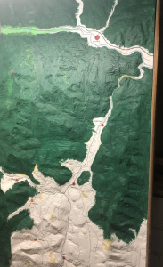
Dave refinished the wooden frame and began painting the landscape in layered greens, imagining the Valley in the fullness of summer. Using aerial imagery and an incredible eye for detail, he coaxed the terrain into focus. Look closely and you’ll see the cliff bands near the summit of Camel’s Hump, the dramatic vertical walls of the Granville Gulf, and countless subtle features that feel unmistakably right if you know this place.
Paved roads are rendered in gray, dirt roads in brown. Recreational trails appear in red—the Long Trail, Catamount Trail, VAST trails, and the Mad River Path—mirroring what you’ll find on our Recreation Map. Dave even used yarn to lay out the roads before painting, pulling it up afterward to leave clean, precise lines.
Filling in the Backstory
A nnative Vermonter from the Bennington area, Dave Reed has been a fixture in the MRV working as a boot fitter, artist, oven builder, sign maker and all around handy guy. He’s always good for a story with a heaping helping of local flavor.
As often happens in the Mad River Valley, the real history emerged not through an archive, but through people.
Thanks to longtime forester and local legend Leo Laferrière, and to Grace Sweet, we now have a much clearer picture of the map’s origins.
Over several generations, the Ward Lumber Company had amassed nearly 30,000 acres of timberland across Moretown, Duxbury, Warren, Waitsfield, and Fayston. In 1968, the Ward family offered those lands for sale, and the Laird Properties New England Land Syndicate was formed to acquire them. (A “syndicate,” as Leo notes, was simply the legal structure of the partnership—clients of Laird, Inc., a New York brokerage firm.)
The purchase was intended as a long‑term investment in what was then a growing Vermont resort region. With little experience managing large forest holdings, the syndicate hired Dan Kiley & Associates, a respected landscape architecture firm based in Charlotte, Vermont, to help imagine potential future uses of the land.
It was this firm that commissioned and produced the relief model of the Mad River Valley—originally highlighting the Ward Lumber lands. While visually striking, the model proved to be of limited practical use at the time. Existing maps already served forestry needs, and many of the proposed development ideas never came to pass. Still, the model endured.

Forester, Tom Sweet worked for the US Forest Service and later for the Ward Lumber Company. He drove the map to VT from New York City onthe top of his micro-bus!
Enter Tom Sweet
In 1979, forester Tom Sweet took over management of the Ward Lumber Company lands, continuing in that role until the property was sold around 1994. Tom later worked as a consulting forester throughout Central Vermont—including here in the Mad River Valley—until his retirement in 2021.
Tom knew the map well. It had lived in offices, been moved from place to place, and at one point famously made the trip from New York City to Vermont strapped to the roof of a VW microbus—about as 1970s Vermont as it gets.
Tom ultimately helped save the model by initiating a conversation about its value and potential future with Eric Friedman. Through a mix of civic‑minded persistence, durability, and plain old happenstance, the map eventually found its way to the Warren Town Hall attic… where it waited.
As Grace Sweet beautifully put it, Tom’s life as a forester was defined by deep satisfaction in the work itself:
“Sixty years and never a bad day in the woods. Bliss!”
A Map with a Purpose
Today—more than 50 years after it was first created—the relief map has finally found its true calling.

Closeup of map in the midst of painting over the white. The roads were laid out with yarn so after painting Dave pulled up the roads leaving an un-painter area so they could easily be drawn in.
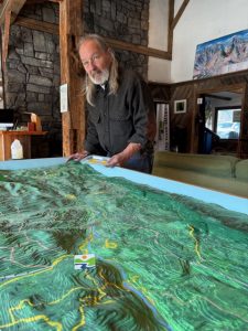
Thanks to Dave Reid’s steady hand and long vision, what was once a dusty, largely forgotten artifact is now the centerpiece of the Mad River Valley Welcome Center. It’s no longer about land speculation or unrealized plans. Instead, it helps visitors and locals alike understand the Valley as it is: interconnected, storied, and deeply shaped by the land.
We’re grateful to everyone who helped fill in the gaps—especially Leo Laferriere and Grace Sweet—for sharing their knowledge and memories. This map’s journey is a reminder that history here isn’t static. It lives in conversations, chance encounters, and the care people take to pass stories along.
After all these years, the map has found real purpose. Around here, that feels exactly right.
Good old Yankee ingenuity, indeed.
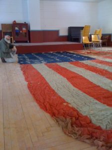
This old flag was also found in the Warren Town Hall attic around the same time. Barryie Simpson, a longtime Warren resident, show off the flag that is now on display in the town hall
A close-up of the relief map as it was found in the attic.
The map in the process of painting in the foliage-summer look Dave Reed decided on.
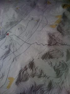
A close-up of the mountain peaks of the relief map created in the early 1970’s.
